


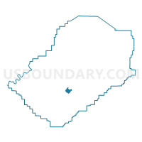
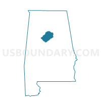
Brighton Senior Citizens Building, Jefferson County, Alabama
About
Outline

Summary
| Unique Area Identifier | 522032 |
| Name | Brighton Senior Citizens Building |
| County | Jefferson County |
| State | Alabama |
| Area (square miles) | 2.09 |
| Land Area (square miles) | 2.09 |
| Water Area (square miles) | 0.00 |
| % of Land Area | 100.00 |
| % of Water Area | 0.00 |
| Latitude of the Internal Point | 33.44089830 |
| Longtitude of the Internal Point | -86.94951250 |
Maps

Graphs
Select a template below for downloading or customizing gragh for Brighton Senior Citizens Building, Jefferson County, Alabama


Neighbors
Neighoring Voting District (by Name) Neighboring Voting District on the Map
- Brooklane Community Center, Jefferson County, AL
- Dunbar-Abrams Community Center, Jefferson County, AL
- Lipscomb City Hall, Jefferson County, AL
- Midfield Community Center, Jefferson County, AL
- Mt. Pilgrim Baptist Church, Jefferson County, AL
- Roosevelt First Baptist Church, Jefferson County, AL
Top 10 Neighboring County Subdivision (by Population) Neighboring County Subdivision on the Map
Top 10 Neighboring Place (by Population) Neighboring Place on the Map
- Birmingham city, AL (212,237)
- Bessemer city, AL (27,456)
- Hueytown city, AL (16,105)
- Midfield city, AL (5,365)
- Brighton city, AL (2,945)
Top 10 Neighboring Unified School District (by Population) Neighboring Unified School District on the Map
- Jefferson County School District, AL (230,679)
- Birmingham City School District, AL (212,237)
- Bessemer City School District, AL (27,456)
- Midfield City School District, AL (5,365)
Top 10 Neighboring State Legislative District Lower Chamber (by Population) Neighboring State Legislative District Lower Chamber on the Map
Top 10 Neighboring State Legislative District Upper Chamber (by Population) Neighboring State Legislative District Upper Chamber on the Map
Top 10 Neighboring 111th Congressional District (by Population) Neighboring 111th Congressional District on the Map
Top 10 Neighboring Census Tract (by Population) Neighboring Census Tract on the Map
- Census Tract 134, Jefferson County, AL (4,838)
- Census Tract 133, Jefferson County, AL (3,588)
- Census Tract 136.01, Jefferson County, AL (3,511)
- Census Tract 139.02, Jefferson County, AL (2,141)
- Census Tract 138.01, Jefferson County, AL (2,122)
- Census Tract 101, Jefferson County, AL (2,007)
- Census Tract 139.01, Jefferson County, AL (1,704)